|
|
| Routes |
|
|
|
|||||||||||||||||||||||||||||||||||||||||||||||||||||||||||||||||||||||||||||
| ... show all routes ... | ||||||||||||||||||||||||||||||||||||||||||||||||||||||||||||||||||||||||||||||
| 18 km | Pizza, Olympiastadion, Angerburger, Postfenn, Olympiastadion, Pizza 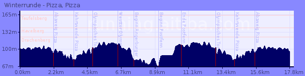
|
|||||||||||||||||||||||||||||||||||||||||||||||||||||||||||||||||||||||||||||
| ... show all routes ... |
|
|
| Routes |
|
|
|
|||||||||||||||||||||||||||||||||||||||||||||||||||||||||||||||||||||||||||||
| ... show all routes ... | ||||||||||||||||||||||||||||||||||||||||||||||||||||||||||||||||||||||||||||||
| 18 km | Pizza, Olympiastadion, Angerburger, Postfenn, Olympiastadion, Pizza
|
|||||||||||||||||||||||||||||||||||||||||||||||||||||||||||||||||||||||||||||
| ... show all routes ... |